Around Me
Search
List
Map
Combined
+
+
Guide
Europe
Germany
Austria
Italy
Switzerland
France
Spain
Greece
Great Britain and Northern Ireland
Czech Republic
Liechtenstein
Iceland
Romania
Belgium
Hungary
Portugal
Slovakia
Ireland
Netherlands
Denmark
Norway
Finland
Malta
Sweden
Slovenia
Lithuania
Serbia
Ukraine
Poland
North America
USA
Canada
Costa Rica
Oceania
New Zealand
Australia
Africa
Egypt
South Africa
Asia
Japan
China
United Arab Emirates
Turkey
India
Azerbaijan
Georgia
Iran
Russia
South America
Brazil
Hiking
Europe
Austria
Germany
Italy
Switzerland
Liechtenstein
France
Iceland
Romania
Belgium
Ireland
Norway
Great Britain and Northern Ireland
Denmark
Sweden
Spain
Portugal
North America
USA
Canada
Oceania
New Zealand
Australia
Biking
Europe
Austria
Germany
Switzerland
Italy
Romania
Spain
Liechtenstein
Great Britain and Northern Ireland
Lithuania
Finland
France
Iceland
Ireland
North America
Canada
USA
Swimming
Europe
Austria
Germany
Switzerland
Italy
Romania
Iceland
Hungary
Spain
Belgium
Slovenia
Malta
Ireland
Netherlands
Great Britain and Northern Ireland
North America
Canada
USA
Attractions
Europe
Germany
Austria
Italy
France
Switzerland
Spain
Greece
Czech Republic
Portugal
Slovakia
Great Britain and Northern Ireland
Hungary
Belgium
Netherlands
Iceland
Ireland
Denmark
Finland
Malta
Liechtenstein
Norway
Romania
Sweden
Serbia
Slovenia
Ukraine
Poland
North America
USA
Canada
Costa Rica
Oceania
New Zealand
Australia
Africa
Egypt
South Africa
Asia
Japan
United Arab Emirates
China
Iran
Georgia
India
Azerbaijan
Turkey
Russia
South America
Brazil
Magazine
News
Award
Active
Culture
Tips
Specials
On Tour
Inside
Hike Rothaar - Image Gallery
Hike
Weather For Hikers
Webcams
Wall
Photos
Hike Rothaar
Hike
Photos
Weather For Hikers
Webcams
Hikes
Europe
Austria
Germany
Bavaria
North Rhine-Westphalia
Sauerland
Bergisches Land
Baden-Württemberg
Saxony
Lower Saxony
Thuringia
Rhineland-Palatinate
Saarland
Brandenburg
Mecklenburg-Western Pomerania
Saxony-Anhalt
Italy
Switzerland
Liechtenstein
France
Iceland
Denmark
Great Britain and Northern Ireland
All countries in Europe
Romania
Belgium
Norway
Ireland
Sweden
Portugal
Spain
North America
Canada
USA
Oceania
New Zealand
Australia
Magazine
News
Award
Active
Culture
Tips
All magazine categories
Specials
On Tour
Inside
Misc.
The Perfect Match
Travel Guide
Map
Sweepstakes
Surveys
© Stefanie Auge, Sauerland-Tourismus e.V.
Rothaarsteig is a popular German long-distance walking trail.
© Stefanie Auge, Rothaarsteigverein e. V. / Klaus-Peter Kappest
The hike starts at the historic town square of Brilon.
© Stefanie Auge, Rothaarsteigverein e. V. / Björn Hänssler
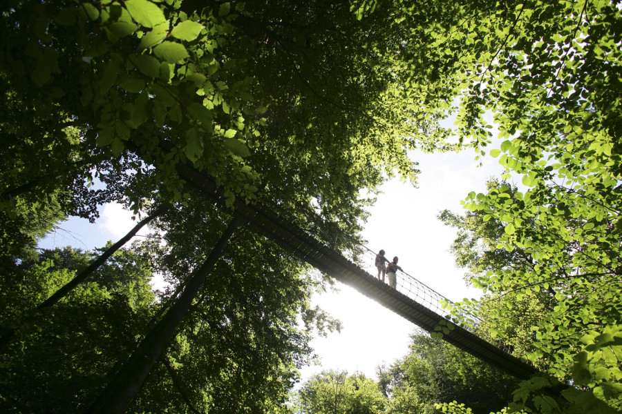
The pendant bridge near Kühhude is one of the highlights.
© Stefanie Auge, Rothaarsteigverein e. V. / TATONKA
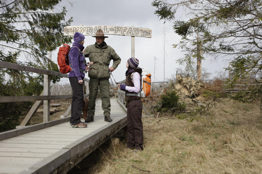
At Kyrill path, visitors can see the damage of the storm that destroyed large forest areas in the region in 2007.
© Rothaarsteigverein e. V. / Kalus-Peter Kappest
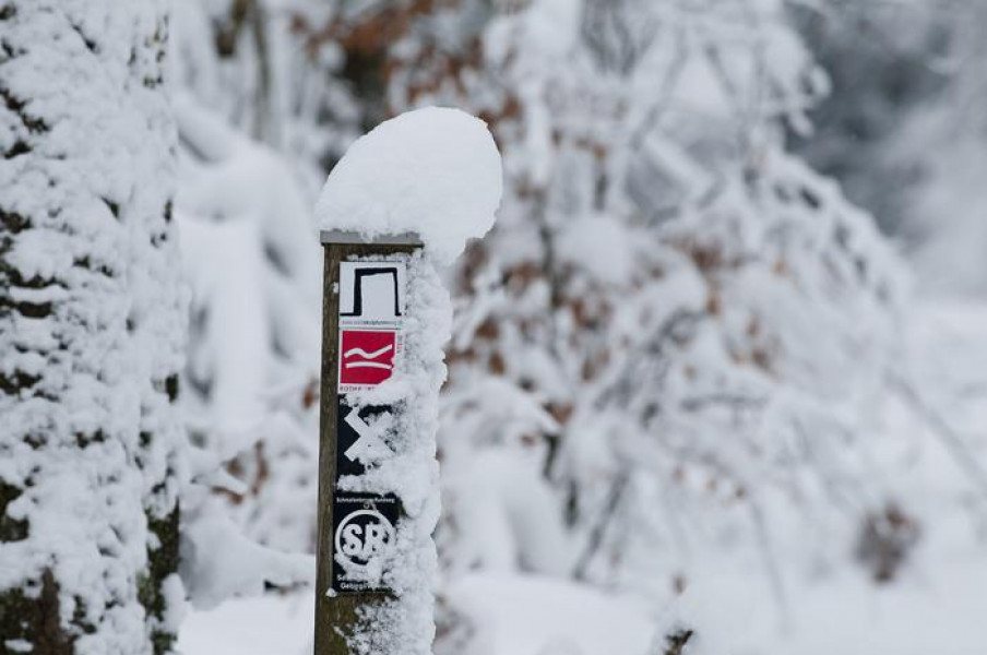
Some stages of Rothaarsteig can be walked all year round. The trail is marked with a recumbent white R on a red background.
© Stefanie Auge, Rothaarsteigverein e. V.
Rothaarsteig offers numerous viewing points. The hike features views of the Sauerland, Wittgensteiner Bergland and Siegerland regions.
Weather
(605
m
)
Today
32
°C
Fri
34
°C
Sat
35
°C
Weather Forecast
Webcams
All Webcams
Nearby
Grönebacher Dorfpfad Trail
3.8
km
Aventura SpielBerg in Medebach
5
km
Skywalk suspension Bridge Willingen
5.9
km
Show all
Winterberger Schluchten- und Brückenpfad Trail
6.4
km
Summer toboggan run Herrloh Blitz in Winterberg
7.7
km
Hochsauerland-Kammweg
8.5
km
Circuit Hochtour Winterberg - North Rhine-Westphalia
9.6
km
Hike Rothaar
19.5
km
Rate the Hike
0
(3)
Share this page
Share
Tweet
Mail
Advertisement
Login