Contents
Description
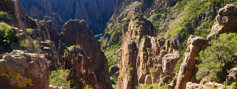
Black Canyon of the Gunnison is an insider tip among the national parks of the region. The gorge is not wider than 366 yd (335 m), up to 900 yd (823 m) deep and 50 mi (80 km) long. No other gorge offers a combination of natural features of such depth and narrowness in combination with such an extreme downhill gradient. The gorge is narrow to such an extent that there is hardly any ray of light reaching the ground, making the rocks appear almost black, which makes the canyon totally living up to its name – a truly black canyon.
Black Canyon of the Gunnison is one of the four national parks in Colorado. If you wish to visit this extraordinary region, you may equally explore both the South and North Rims. As there is no bridge connecting the two sides of the canyon, you need to take into account a detour of up to two or three hours before you reach the other side.
Both sides of the canyon may be explored on various ways as there is a road on each side, offering many viewpoints. Mind that the road along the North Rim is not tarred and therefore remains closed in winter. Don't despair, it's worth leaving one's car aside for some time. There are many hiking paths, paved and unpaved, allowing you to explore the entire area or you opt for a horse ride. At the Gunnison, you are also given the possibility to go fishing or embark on a kayak tour, which is only recommended to experienced kayak enthusiasts, though, due to strong currents. In wintertime, you may practise cross-country skiing or go on a snowshoe hike. Due to the camping grounds on both sides of the canyon, you may stay here overnight.
The South Rim is more popular among the visitors as it offers more viewpoints than its northern counterpart. At the South Rim Visitor Center you may learn more about the Black Canyon and also ask questions, which the rangers on-site will be delighted to answer. When here, you should not miss paying a visit to the “Painted Wall”. Reaching a height of 2264 ft (690 m), it is almost double the height of the Empire State Building and the highest vertical rock face in Colorado. The term “Painted Wall” goes back to the white stripes coating on the rock faces. They appear as if they were painted on the rocks. Here at the South Rim, you additionally have the opportunity to get to the Gunnison. You just take a right turn into East Portal Road. Paying close attention to the road is the order of the day as the road is very steep and utterly curvy. Vehicles longer than 22 ft (6.7 m) are not allowed on this road.
Historical Information
For a period of 2 million years, the river Gunnison has formed the Black Canyon of the Gunnison. As the river drops an average of 96 feet per mile, it can naturally unfold energy to such an extent that it surely makes its way through 2 billion year old rocks deriving from the Precambrian. Before the river was dammed, the river could accumulate a speed of up to a 2.75-million-horsepower force rushing through the Black Canyon.
In order to protect the inhabitants as well as the landscapes, the Black Canyon of the Gunnison was declared a national park in 1999. The locals had been fighting for it to be listed in this category since the 1930s. They succeeded only partially as the Canyon was listed as an official National Monument in 1933. In total, 14 mi (22.5 km) of the gorge have been under special protection since 1999.
How to get there
The national park is located around 250 mi (400 km) southwest of Denver. To get to the South Rim, you start your trip in Denver and head towards the Gunnison via the US highway 285 and US highway 50. You then change to Colorado highway 347 just before Montrose.
Coming from the west, you go as far as the Grand Junction on the Interstate 70. This is where the US highway 50 begins. Follow the road up to just after Montrose until you end up on Colorado highway 347.
In case your destiny is the North Rim, you change onto CO 92 at Delta, which can also be accessed via US highway 50.


