Contents
Route description
Allgäu launched a trilogy of hiking routes in summer 2014. The three routes – Himmelsstürmer (“Heaven hotspur”), Wiesengänger (“Meadow walker”) and Wasserläufer (“Water runner”) – were designed to allow visitors to explore the towns and landscapes of the Allgäu across a whole host of different stages.
The routes lead through 33 partner towns, all of which are designated as either portal, stage or themed towns. Each stage town offers a starting point for a section of the route, with plenty of information provided on the stage ahead. These points are always marked with a little stone man – the mascot of the new trilogy of hiking trails – something which always makes them easy to find. The three routes are each aimed at telling different tales of Allgäu. These themes are primarily connected with the portal towns, which are central to these stories. The stage towns also offer further information on the nine themed areas featured in the trilogy. True to their name, the stage towns form the start and end points for each stage, though there is usually much more to discover here too. The portal and stage towns can be best discovered on one of the trilogy routes, which have all been designed to visit special towns. The themed towns, which are not necessarily connected by routes or themes to the other areas in the trilogy, often tell their own independent tales and are just as fascinating.
Water as far as the eye can see
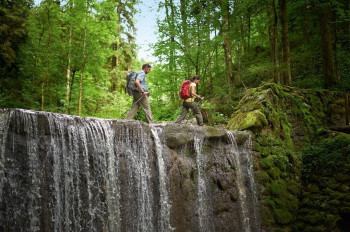
The Wasserläufer route explores the Alpine foothills between Lindenberg in the West and Halblech in the East. The 30 stages on this route are categorised as intermediate and extend between 13 and 27 kilometres in length. While the landscape to the West is dominated by waterways and waterfalls, the East features a plethora of lakes. The 374 km route is designed as a circular tour, making entry possible anywhere on route and allowing day hikers to take on individual stages.
Aquatic diversity
The towns of Lindenberg and Scheidegg, located on the sunny plateau above Lake Constance, are the portal towns for this water-themed route. The landscape explored along the individual stages was once shaped by the ice of a huge glacier. The landscape left behind by the ice is incredibly diverse – from small streams and thrashing waterfalls to tranquil lakes. In Oberreute, a stage town on the water-themed route, the Hausbachklamm gorge is the undoubted highlight and a must-see for visitors to the area.
Wonders in the distance
Part of the Wasserläufer route joins the “Panoramalogen” themed walk. The portal town of Nesselwang, which marks the boundary between the Alpine foothills and the Alps proper, offers up stunning views of the hills and plateaus of the Allgäu, as well as the mountains and the attractive lakelands beyond. Here you can see Allgäu from a completely different perspective. This is not only a treat for the eyes, but the stage town of Oy-Mittelberg also allows you to indulge your sense of smell too. Primavera offers aromatherapy treatments, while Bühler roasts its coffee here. The freshly cut hay and the smell of the wood cut and dried in the area make this town a truly memorable olfactory experience.
Fairy tale realms
The “Schlosspark” themed area whisks you away to enchanted places, mysterious lakes and of course the fairy-tale castle which crowns this entire area. Füssen is the portal town in this area, a town which already offers us views of Neuschwanstein, King Ludwig II.’s enchanting castle. But the castle isn’t the only reason to visit this historical town, and a walk through Füssen is also well worthwhile. In the stage town of Marktoberdorf, you can find out about local legends while you follow in the footsteps of kings in Halblech – a place where the royal family once strolled and hunted. Pfronten’s beautiful churches are also well worth a visit.
Where to eat
As the stages on this route lead through numerous towns, you don’t have to worry about going hungry or thirsty. You can choose from 49 partner hotels as accommodation on the route, all of which hold the seal of quality “Wanderbares Deutschland”.
Interesting facts
- With an overall length of 383 km the hike is among the 3 longest hikes in Germany available on TouriSpo.
- Elevated between 672 m and 1,699 m, the hike is among the 10 highest elevated hikes in Germany. You're facing an uphill climb of 17147 vertical meters on this hike. This is quite much. You should be fit to do this track. This makes the hike one of the 3 hikes with the most ascent in Germany.
- In case of good weather conditions, the hike can also be done without bringing your hiking boots. There are places to buy beverages and food along the track. However it’s always recommended to bring enough water and food along with you.
Highlights of the tour
The Wasserläufer route takes in beautiful lakes and rivers, and also offers up some town highlights too. As the route is categorised as intermediate, it’s not particularly demanding, but does still offer at least the feel of a true Alpine hike. This makes the Wasserläufer route the ideal happy medium between the gentle Wiesengänger route and the challenging Himmelsstürmer route. The area around the “Panoramalogen” is the best place to admire Allgäu’s variety, while the “Schlosspark” themed area is the undoubted cultural highlight.
Variations
From Oberreute, connoisseurs should take a brief detour to the spa town of Weiler-Simmerberg. Emmentaler was successfully produced for the first time here. The culinary delights here are rounded out by a chocolate and praline workshop, breweries and artisan producers of natural and herb products.
In the “Panormalogen” themed region, Burgberg offers insights into the history of mining, while Rettenberg is the place to find out about Allgäu’s myths and legends.
Getting here
By car: If you’re heading to Allgäu by car, take the A7 from Ulm to Füssen or the A96 from Munich and Lindau.
Public transportation:
Oberstdorf and Lindau are both part of the Allgäu Express (ALEX) service which starts in Munich. The Bavarian railway service (Bahnland Bayern) runs between the individual towns in the region.
Allgäu-Airport Memmingen is the central hub for air passengers here. Alternatively, you can also fly into Friedrichshafen, Munich or Stuttgart.


