Contents
Route description
Start at the top station
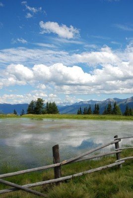
Technically your tour starts at the valley station Rosskopf. From there you will take the cable car up 1800 meters (1968.5 yd) to the top station. The tour starts at the trail called Ridnauner Höhenweg marked with the number 24. This trail is a rather curvy and twisted route. Once you get to the intersection with the trail Flaner Jöchl, you start following the latter in a sort of circular route around the mountain. On the crest of the mountain you will then reach the biotope Kastellacke. Here you can have your first intermediate stop. The protective area lies within a beautiful mountain landscape you can fully enjoy while resting.
Short but diversified trail
You continue hiking on the Dolomieu Almen Trail (19A). The hike is relatively easy because you will be hiking mostly downward until you reach the bank of the Walmingback creek. Traverse the creek and on the other side you will find a possibility to rest at the Vallmingalm mountain hut at 1830 meters (2001.3 yd). After that you start hiking the trail number 34 A, which will be the steepest hike on your tour. It leads up almost 2000 meters (2187.2 yd), where the trail splits up again. Here you have to continue hiking on trail number 24. Through that you have entered the last stage of your tour. Over the two rest-stops Sterzinger Haus cottage and Sternhütte cottage you will get back to the top station of the mountain.
Where to eat
All the way in the beginning of your tour you can make a stop at the top station Rosskopf and grab a bite to strengthen yourself before or after your hike. But also on your tour there are enough possibilities to make a rest-stop. After you hiked about half of your tour, you can stop at the Vallmingalm cottage. On the last stages of you tour you will find more possible stops, such as the Sterzinger Haus cottage and the Sternhütte cottage, which both offer food and a place to rest.
Interesting facts
- You're traveling a distance of 5 km on this easy trail. The hike is therefore not too long. The average length of all hikes in South Tyrol is 12 km.
- You're facing an uphill climb of 257 vertical meters on this hike. The highest point of the track is 1,984 m above sea level.
- Don’t hesitate to take your kids along on this easy hikes.
- In case of good weather conditions, the hike can also be done without bringing your hiking boots. There are places to buy beverages and food along the track. However it’s always recommended to bring enough water and food along with you.
Highlights of the tour
This tour is especially interesting and fun for families, because in particular the little hikers are going to be blown away by this tour. All the way in the beginning of the tour you will find a petting zoo called “Rossy Park”, which is the first highlight and you should definitely schedule some more time. Here you can not only experience smaller animals like bunnies, miniature goats or ponies, but an absolute main feature are the Lamas. You can either watch them from further away or even participate in a Lama-Trekking-Tour once a week.
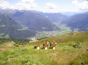
After all this action in the beginning of the tour, you will be able to relax and enjoy the calmness and serenity of the mountain further up the trail, particularly when you reach the biotope Kastellacke. You get the best views if you hike during good weather. The sights and panoramas are incredible and almost endless on this tour. You get astounding views onto opposing mountain landscapes and you should consider resting a little bit longer next to the beautiful lake over-viewing the idyllic lands. You should definitely stop at the Vallmingalm, which is a rare traditional South Tyrolean village and still possess a down-to-earth atmosphere worth visiting.
Getting here
By car
Starting in Bozen
You drive out of the city taking the SS12 and then change onto the Brennerautobahn (highway) A22, which you will have to follow for about 60 kilometers (37.3 mi). Get off of the highway at the exit called Sadobre and keep driving in the direction of Sterzing. After some time you will have reached the town center and driving down Brennerstraße street you will reach the valley station Rosskopf.
Starting in Innsbruck
Leave the city via the Inntal Autobahn (highway) A12 and then change on the Brennerautobahn (highway) A22 and follow that road for 34.5 kilometers (21.4 mi). After that you will follow the E45 and take the exit in the direction of Sterzing. After some time you will reach the town center and driving down Brennerstraße street you will reach the valley station Rosskopf.
Starting in Brixen
Leave Brixen in the direction of the district of Vahrn. After that drive onto the SS12. Take the access road in the direction of Bruneck and drive via SS49 onto the Brennerautobahn (highway) A22. Follow the highway until you reach the exit Sadobre. There you just follow the road in the direction of Sterzing. After some time you will reach the town center and driving down Brennerstraße street you will reach the valley station Rosskopf.
You will be able to park at the valley station.
By public transportation
Starting in Brixen there is a train, which leaves regularly for Sterzing. From the train station it is a distance of 1,2 kilometers (0.7 mi) to the valley station. Besides a train station, Sterzing offers other possible public transportation, so you are able to reach the valley station with no problem.


