Contents
Route description

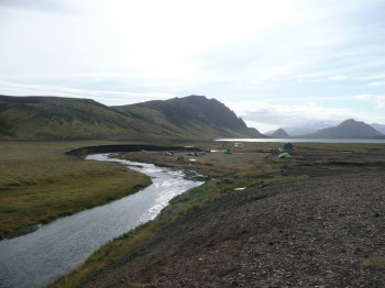
Laugavegur is one of the most popular hiking trails through the Icelandic wilderness. It connects the two natural reserves Landmannalaugar and Þórsmörk. The path leads through an incredibly diverse landscape. You get to see mountains in all colours of the rainbow, impressive glaciers, hot springs, rivers and lakes. The hike usually takes four days. As it can get dangerous in bad weather, the right equipment is key, and hikers should be well prepared to tackle this trail.
- Day 1: From Landmannalaugar to Hrafntinnusker
12 kilometres; 4 to 5 hours - Day 2: From Hrafntinnusker to Álftavatn
12 kilometres; 4 to 5 hours - Day 3: From Álftavatn to Emstrur (Botnar)
15 kilometres; 6 to 7 hours - Day 4: From Emstrur (Botnar) to Þórsmörk
15 kilometres; 6 to 7 hours
Sturdy shoes necessary
Overnight stay available
Eating options available
Interesting facts
- You're traveling a distance of 56 km on this moderate trail. This makes it a relatively long hike. The average length of all hikes in the Regions of Iceland is 61 km.
- Elevated between 215 m and 1,066 m, the hike is among the 3 highest elevated hikes on Iceland. You're facing an uphill climb of 1465 vertical meters on this hike. This makes the hike one of the 3 hikes with the most ascent on Iceland.
- Sturdy hiking boots are recommended on this track. There are places to buy beverages and food along the track. However it’s always recommended to bring enough water and food along with you.
Videos
The Laugavegur Trail, Iceland | 07:44
Laugavegur - Iceland 2017We hiked the Laugavegur trail in Iceland over 5 days in...


