Contents
Route description

Start in the small village of Șiria
Once you arrive at Șiria, you now run out of the village in an easterly direction until you reach the edge of the forest. You walk on a paved road and then change to a gravel path as soon as you reach the first trees. Since the hike does not have a high degree of difficulty, it does not go up too steeply at first, so that you can find your way very well into the hike. Already after the first meters you run out of the forest and have an early view of the surrounding landscape. The gradient isn't very steep, but it's still a long way off. Only when you reach an alpine meadow does the route level off slowly. At this point you can also take your first break, because you can already see some of the surroundings from this height and you should also enjoy the quiet atmosphere in the middle of the alpine meadow .
Up to the fortress
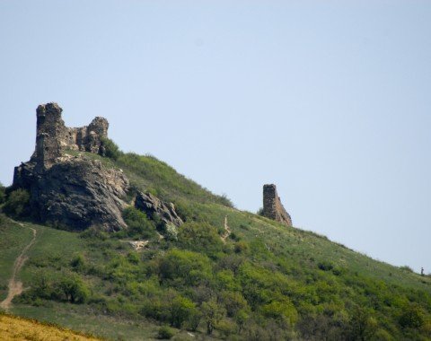
After this intermediate stop you cross the meadow and then take the small path at the other end, which should already signpost the fortress. The path now also meanders steeply up the hill, slowly but surely approaching your destination. Soon you should be near the fortress, where there are two ways to climb it. On the one hand you have the possibility to reach them coming from the north, on the other hand you have the possibility to hike from the south to the endpoint. However, the southern variant is much more relaxed and less strenuous, so you should prefer it if you don't have enough energy left from the ascent. When you finally arrive at the top of the fortress, you should plan a longer stay here, because the view is really unique. So you can even see parts of the Carpathians and have the perfect background for some nice souvenir photos. Then you walk the same way in the opposite direction back into the valley.
Where to eat
At your starting point in Șiria you will find opportunities for refreshment before and after your hike. On the hike itself there are no places to stop for refreshments, so for this occasion you should take provisions with you.
Interesting facts
- You're traveling a distance of 4 km on this easy trail. The hike is therefore not too long. Average length of all hikes in Romania is 18 km.
- The hike is one of the family friendly trails in the region. The hike is also perfect if the kid’s wanna bring their dog on the trip.
- Hiking boots are not required, but the hike might be more enjoyable with sturdy footwear (especially in wet conditions).
Videos
Highlights of the tour

Since the hike is only about 4 km long and the ascent can also be accomplished with average physical condition, the route with its medium level represents the perfect day excursion. The tour can also be walked with children, so this is a hiking pleasure for the whole family. In addition, this tour always offers a wonderful panorama, which is perfect for beautiful landscape shots. The fortress Șiria is of course also a highlight of the tour as a stage destination. In its past it had different functions, ranging from a simple residence to the central location of the peasant revolts in the 15th century. Although only ruins of the fortress remain today, as it was partially destroyed by the Habsburgs in 1784, it still towers impressively over the city.
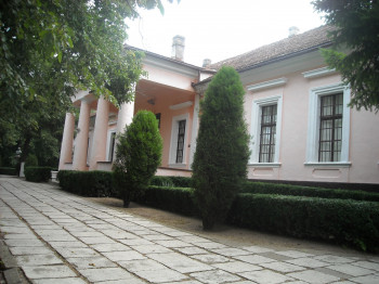
You can also find some highlights in Șiria itself, which you can enjoy before your tour up to the fortress. Especially interesting is the Castell Bohus, because this was an important place at the time of the Hungarian Revolution in 1848 and 1849. In the rooms of the fort the surrender treaty of the revolutionary side was signed. Originally the building was built by the Bohus family of the same name and comprises a total of 30 rooms.
Getting here
By car
From Timisoara
You first leave the city via the DN6 and then switch to the DJ691. Via the motorway feeder road you reach the A1, which you follow for the next 32 km. Leave the motorway at the exit in the direction of Arad Süd and take the second exit onto DN69 at the following roundabout. On this road you now cross Arad and continue your journey on the DN7, which you follow only for a short time and change at the next roundabout to the DJ709, which takes you directly to Șiria.
From Oradea
You first drive out of Oradea and take the Strada Oneștilor for this. You follow the road until you can change to the DN79, which you follow for about 30 km and also pass through Salonta. You stay on the DN79 and turn left at Nadab onto the DJ792. On this road you can also reach Seleuş and turn right onto DJ709, which will take you directly to Șiria.
From Deva
You leave the city via the DN7 in the direction of Mintia and follow it for the next few kilometres. When you arrive at Păuliș, turn right onto DJ708B, which will take you directly to Șiria.
Parking is available in the streets of Șiria.


